-
We first published this look back at a momentous moment in L.A. weather history in April 2023. We're bringing back top-of-mind ahead of a storm scheduled to hit Southern California Saturday (Feb. 3) night.
-
The National Weather Service is warning this could also be a historically significant storm. Here's their forecast from Friday afternoon:
-
"Flooding issues will not be confined to just the foothills, mountains, and burn ares. ALL AREAS, INCLUDING HIGHLY POPULATED URBAN AREAS, WILL BE AT RISK FOR LIFE-THREATENING FLOODING. Streams and small rivers, as well as the Los Angeles River through the San Fernando Valley and metro LA will rise quickly and turn into very dangerous raging rivers. Many roads will be impassable due to flooding. Numerous mud and rock slides are expected in the foothills and mountains. Evacuations may be required in some areas, especially near recent burn scars."
When the first rain drops started to fall early in the winter of 1861-1862, ranchers and farmers living in the small pueblos of Los Angeles, San Bernardino and San Diego breathed a sigh of relief. It was the end of years of devastating drought.
But then came too much rain.
On Christmas Eve 1861, the rain started in Southern California and didn’t stop for nearly 28 days. Just two weeks later came another storm — then another.
That winter would become “one of the biggest wettest, coldest, and probably most historic winters in the West’s past,” said Will Cowan, who received his doctorate in environmental history from USC. He wrote his dissertation on the storms of 1861 and 1862, called by those who lived through it “The Big Winter.”
Back then, the L.A. River, usually a lazy stream in the middle of a wide and mostly sandy riverbed, became a torrent so big it combined with the San Gabriel River, permanently shifting the L.A. River’s mouth from what’s now Venice to Long Beach. The Santa Ana River, the largest river in the region, exploded into a miles-wide deluge.
“The original triangle of SoCal, every major settlement was not just inundated, but practically destroyed,” said Cowan.
Further north, the Central Valley was transformed into an inland sea. The booming city of Sacramento had to be navigated by boat.

Hundreds of people drowned. So did thousands of cattle, upending the state’s economy.
The series of storms that winter were what we now call atmospheric rivers. And, a hotter climate is making them more extreme.
But even this year’s winter deluge, though historic, simply doesn’t compare to storms of the past, including 1862, Cowan said.
“What is happening with human-caused climate change, it is going to exacerbate what's kind of already been occurring,” Cowan said. “Yes, things have changed. What we have done is going to change things more dramatically.”

It comes down to a changing water cycle: When we burn fossil fuels like coal, oil and methane gas, greenhouse gases are released into the atmosphere, which in turn heats up the planet. That heating leads to longer and hotter droughts, causing more water to evaporate into the atmosphere. That water eventually comes back down in the form of more intense storms.
Of course, not every climate change-fueled severe storm will be a megaflood. Megafloods are considered to have a 1-in-1000-year chance of occurring any year.
But a recent study out of UCLA found human-caused climate change has doubled the chances of megafloods similar to, and likely bigger than, 1862. Those are still relatively slim chances, but even the designation “1000-year-storm” can inspire a sense of complacency, said Cowan. It’s not about storms like this coming every 1000 years — it’s about the increasing probability of them coming any given year.
“If someone told me I had a one-in-a-thousand chance to win the Super Lotto, you know I'm playing,” said Cowan. “And yet people are like, ‘Ah, it won't happen this year.’”
-
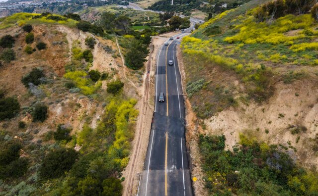
You've probably heard terms like "100-year flood," "500-year flood" and "megaflood." These are terms that have been developed based on historical rainfall and hydrological data to provide estimates on flooding of differing severities.
-
These terms also help designate flood insurance maps used by the Federal Emergency Management Agency, or FEMA. They also help engineers know how to build to withstand certain extreme scenarios. L.A.'s flood control system is built to withstand 100-year flood flows, but aging infrastructure challenges that.
-
“It rains at different amounts in different places and we see these events that come and go, and they may not exactly match what we've designed for, but the hope is that we've done a reasonably good job planning for this type of event so that the consequences are not too catastrophic,” said Brett Sanders, a UC Irvine engineering professor whose research focuses on flood resilience.
-
- A 100-year flood doesn't occur every 100 years. Rather, it has a 1% chance of occuring any given year.
- A 500-year flood has a 0.2% chance of occurring any given year.
- A megaflood is most commonly considered to be a 1,000-year flood, or a flood that has a 0.1% chance of occurring any given year.
-
But all of those chances are going up as the climate crisis changes the global water cycle. A recent UCLA study found chances of a megaflood have doubled due to the changing climate.
Going to war with floods
When the 1862 floods covered Southern California, the Southland’s three major rivers — the Los Angeles, San Gabriel and Santa Ana — were free to flow across sandy floodplains now home to millions of people. Those rivers and the swing from drought to flood literally shaped the Southern California landscape for millennia.
Local tribes knew this pattern and would move with the changing landscape, establishing their villages far from riverbanks and getting out of the way when signs in the weather indicated a potential for a big storm. Having lived with this cycle for thousands of years, native Californians didn’t see floods as an enemy, but as a needed and respected part of the landscape, Cowan said.

Mexican ranchers and farmers in the region also had an understanding of the unpredictable nature of southwestern rivers.
“When Anglos first came to California, they kind of made fun of many of the Mexican settlers because they'd see the Mexican pueblos up on higher ground or on the foothills and think, ‘Why would they set themselves up so far away from the river?’” Cowan said.

Soon, they would learn how wrong they were.
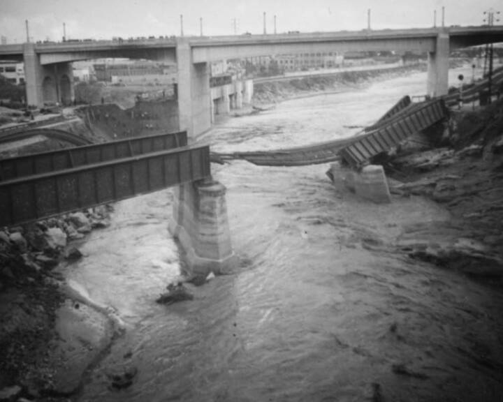
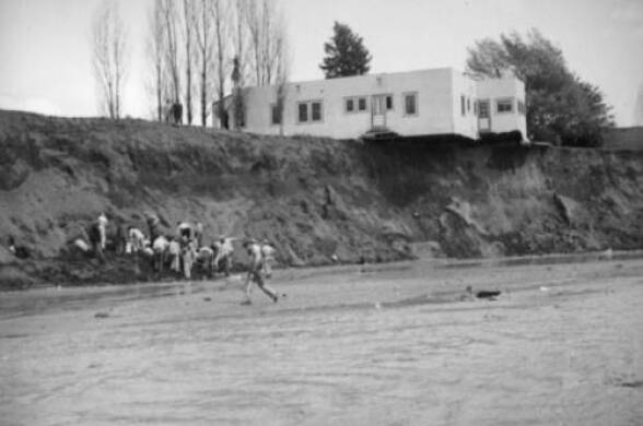
The Gold Rush, Civil War, World War I, and the booming 1920s brought more and more people west to sunny Southern California. That population growth coincided with a series of devastating floods between 1815 and 1938. Calls for flood control — for the region’s rivers to be “tamed” — grew. By 1938, work began to straitjacket the L.A. River with concrete. The 51-mile engineered riverway was completed by 1960.
The engineering of the very landscape is why a flood at the same scale as 1862 would likely look a lot different today. But the concentration of people in a paved-over floodplain that keeps water from sinking into the ground could cause devastating, even deadly consequences.
But it’s really hard to imagine that situation in today’s L.A. (though the U.S. Geological Survey did an analysis of the scenario back in 2010).
“By re-engineering the landscape, by taking floods off the land … if you don't see it … out of sight, out of mind,” said Cowan.
Challenged infrastructure
Researchers say the current flood control system is no match for storms of the future.
-
Most of us here in Southern California live in an area with some type of flood risk. L.A. County has a map to determine what type of flood zone you're in. You can search for your city or neighborhood here.
In the L.A. Basin, a study out of UC Irvine found that nearly a million people live in an area that is at high-risk for flooding in a more likely 100-year storm event. The study found cities along the lower part of the L.A. River — including Bell Gardens, Carson, Paramount City, and Compton — would see some of the most severe impacts, such as water spilling over the top of flood channels and waist-high flooding.
“The flood risk facing cities is bigger than what federally defined maps would suggest,” said Brett Sanders, a UC Irvine engineering professor and lead author of the study.
When it comes to adapting infrastructure, Sanders said there are several options:
- Build bigger dams and higher flood channels and levies.
- Slow down and capture water higher up in the watershed, so not as much flows to the lower watershed.
- “Free” the river: Expand green space and restore wetlands in the floodplain to slow down and capture water across the watershed.
- Incentivize people to relocate out of the highest-risk floodplains, and disincentivize new development in floodplains.
- Retrofit and adapt existing housing to better cope with bigger floods.
“The day of us building concrete, channelized systems is pretty much over,” said L.A. County Public Works Director Mark Pestrella.

We're standing at the Hansen Spreading Grounds in Sun Valley, in the upper part of the L.A. River watershed. It’s one of 27 spreading grounds (essentially engineered wetlands) and 14 dams that both control floods and capture water to boost local drinking water supplies.
Here’s how it works: The Big Tujunga Dam blocks the natural flow of the Big Tujunga Creek, one of the L.A. River’s main tributaries. The dam captures rain and snowmelt that can then be released in a controlled manner into the Hansen Spreading Grounds below, making room in the dams while capturing water underground that would otherwise be shunted down the L.A. River and into the ocean.
-
Decades of industrial contamination has left many of the natural underground aquifers in the San Fernando Valley too contaminated to store water for the future … a big reason why about 50% of the water that ends up in the L.A. River watershed still goes to the ocean. A $600 million cleanup project aims to rectify that.

During this winter’s march of atmospheric rivers, it was a round-the-clock effort to determine water releases from the dams to free up room for more rain, but not release too much too fast to cause a flood issue, Pestrella said.
“The engineers in our shop are absolutely seeing the impacts of [climate change] and it is taking the form of weather whiplash, which means extremes on both ends,” Pestrella said. “We've been investing and maintaining this system so it can handle this weather whiplash. We're basically getting the same amount of water, just quicker. So that means we're going to have to probably double down on the frequency of our maintenance.”
That said, Pestrella isn’t losing sleep over megafloods.
“It's not keeping me up at night,” Pestrella said. “I want people to know that because they've invested in a flood control system here that's pretty incredible.”
Pestrella said the county has captured near record amounts of stormwater this year — 300,000 acre-feet so far, about 60% of the city of L.A.’s annual average water use — while preventing major flooding. Pestrella said he’s confident the system can deal with more water as long as maintenance can keep up.
But funding for some of the needed maintenance — such as getting fire-caused mud flows out of dams — is a major challenge, Pestrella said. Still, he said improving existing infrastructure and installing new technologies is the path forward for large-scale flood control and water capture when you can’t go back and change the past.
“Early land use decisions have somewhat locked us into the system that we have in Los Angeles,” said Pestrella.
And with a lack of physical space in a crowded urban area for expanding spreading grounds like this, Pestrella said that's why the county is working on turning more parks into water-capture systems. Sun Valley Park is one example in the upper watershed, as are large medians such as one being converted for stormwater capture and improvements in East L.A.

An old approach for a new climate
Melanie Winter, a longtime L.A. River advocate and director of nonprofit The River Project, said maintenance and engineered efforts in parks and medians can’t keep up with a rapidly changing climate.
She said as floods get bigger, much more drastic action is needed, such as incentivizing people to move out of the most flood-prone spots in the L.A. River’s floodplain and restoring those areas to a natural state, so the river has room to flood. A plan to buy back land in some of the most risky areas of the floodplain over a 30-year period was considered back in 2015, but never implemented.
“It's either we make some radical transformations now or there's going to be some radical pain,” Winter said. “We can retrofit back and get that stuff right that creates a Los Angeles that everybody can walk to a park … The temperatures go down, the habitat and biodiversity increases. You have a much more reliable local water supply. There's native landscapes. We're not wasting water on things. It's very, very doable.”


That idea isn’t new. In 1930, eight years before ground was broken to turn the L.A. River into a massive concrete channel, a plan made the rounds to keep the river an open park space, an “Emerald Necklace,” that connected the future city. But business and development interests led to the plan being abandoned.
In the decades since, Winter and other Angelenos have worked to bring pieces of that idea back and undo the damage of channelizing rivers and paving floodplains.
Winter said Johnny Carson Park in Burbank is an example that can be replicated along creeks and streams across the county, and ultimately the L.A. River itself.
At the park, a trickling creek surrounded by willow and cottonwood trees runs under wood bridges. It’s beautiful, except for the trash that’s piled up in it.
“This was a creek, a small tributary to the [L.A.] river that had been put in a pipe underground,” Winter said. “When they created this park, they realized, ‘Oh, right, that's there. Let's open that up. Let's let it be a creek again.”
In 2016, Burbank renovated the park and “daylighted” the creek. Now it can capture water that trickles into the groundwater basin, as well as alleviate flooding by slowing that water down and spreading it out in the park. It’s a low-maintenance flood control channel that now also supports local wildlife and provides green space for the community.

“This sort of intervention is an answer to just about every climate challenge we have,” Winter said. “It keeps our local water resources here. It reduces temperatures. It expands biodiversity, it provides for open space. Most of the time it'll just be a phenomenal resource for communities. And then occasionally you wanna give it the room to do what it does, which is flood.”
This is what’s called a “nature-based” approach to flooding and water capture. Most of the stormwater capture efforts involving parks have involved an engineered version of this: installing underground filtration tanks in existing parks, while renovating those parks based on input from the community.
Winter said that's an expensive approach and that there are many areas where rehabilitating the original habitat would have outsize impacts: for example, the 2000-acre Sepulveda Basin. Since it’s high in the watershed, it would help alleviate flooding downstream.
The current L.A. River master plan lays out various projects to green the river — some nature-based, some more nature-inspired and others heavily engineered. Winter, though, worries the climate crisis will outpace and overwhelm such plans.
“If you plan ahead and you invest ahead, it's a lot less expensive than trying to clean up after a disaster,” Winter said. “We either choose to do this before things get really bad, or some of these shifts are gonna be foist upon us.”